浪漫玻利維亞四天
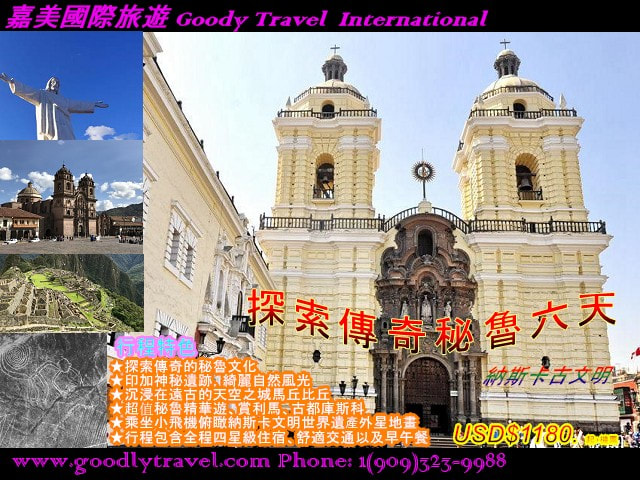
納斯卡古文明驚奇祕魯 六天
|
傳奇祕魯+絕美玻利維亞八天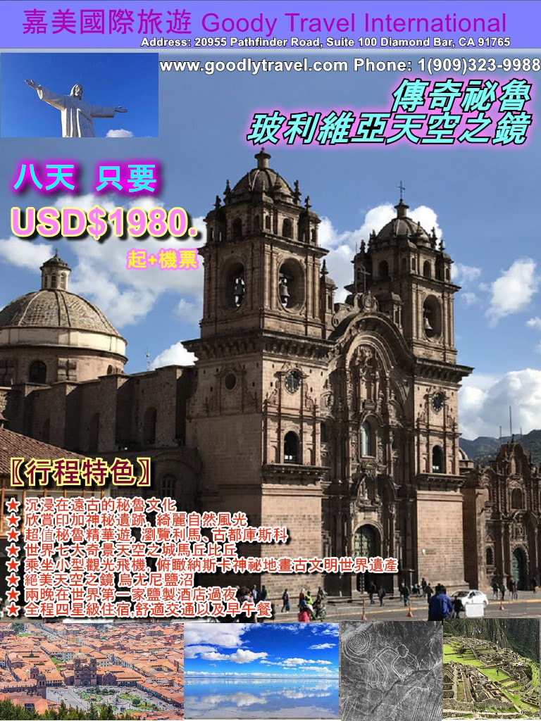
|
美洲文明發源地 墨西哥
墨西哥是美國和中美洲之間的國家,以其太平洋和墨西哥灣海灘以及山脈,沙漠和叢林的多樣化景觀而聞名。 遍布墨西哥全國有特奧蒂瓦坎(Teotihuacán)和瑪雅(ChichénItzá)等古代遺址,亦留有西班牙殖民時期的城鎮。 在首都墨西哥城,可以看到高檔商店,著名的博物館和美食餐廳結合現代生活。
Mexico is a country between the U.S. and Central America and it is known for its Pacific and Gulf of Mexico beaches and its diverse landscape of mountains, deserts and jungles. Ancient ruins such as Teotihuacán and the Mayan city of Chichén Itzá are scattered throughout the country, as are old towns from Spanish colonial era. In the capital, Mexico City, upscale shops, renowned museums, and gourmet restaurants cater to modern life.
Mexico is a country between the U.S. and Central America and it is known for its Pacific and Gulf of Mexico beaches and its diverse landscape of mountains, deserts and jungles. Ancient ruins such as Teotihuacán and the Mayan city of Chichén Itzá are scattered throughout the country, as are old towns from Spanish colonial era. In the capital, Mexico City, upscale shops, renowned museums, and gourmet restaurants cater to modern life.
۞ 奇琴伊薩
奇琴伊薩 ChichénItzá
(可安排下水遊泳,請內著泳衣攜帶毛巾與幹衣物,天坑有更衣室與冷水淋浴)
奇琴伊察是墨西哥尤卡坦半島YucatánPeninsula上瑪雅遺址的複合體。 是瑪雅文明世界末日論的起源地 。瑪雅語Chich'en Itza的意思是「在伊察(人)水井口」。這一名稱在前哥倫布時期是通用名稱,同時該城市在古代史料中也被稱為Uucyabnal,即「7個偉大的統治者」。一個巨大的階梯卡斯蒂略金字塔,被稱為El Castillo 又稱羽蛇神金字塔,城堡,瑪雅金字塔,墨西哥金字塔或庫庫爾坎神廟,在這個古老的城市占主導地位,從公元前600年到12世紀,這座城市茁壯成長。 金字塔的地基呈方形,四邊依階梯上升,直至頂端的廟宇。在春季和秋季的晝夜平分點,日出日落時,建 築的拐角在金字塔北面的階梯上投下羽蛇狀的陰影,並隨著太陽的位置在北面滑行下降。 圖形石雕在球場,勇士殿堂和骷髏牆等建築物中存活。 夜間聲光顯示照亮了建築物的複雜幾何形狀。奇琴伊察有很多精美的石頭建築,以不同程度的保留到了今天,這些建築曾被作為神廟、宮殿、舞臺、市場、浴池和球場。
(This location is open for swimming. Please wear swimwear inside the clothing and bring towels and additional clothing. The changing rooms and cold water shower rooms are available)
ChichenItza is a Mayan ruin complex on the Yucatan Peninsula. The Mayan dooms day theory originates from this place. In the Mayan language, “Chich’en Itza”, bears the meaning of “the well of Itza”. The name of the place has been around since Colombus’ time. At the same period, historical record also call ChichenItza “Uucyabnal,”which means “the seven great rulers”. In this ancient city, the giant step pyramid El Castillo (also named “the feathered serpent pyramid,”the castle, the Mayan pyramid, Mexican pyramid, and the temple of Quetzalcoatl) is the most famous structure of the ancient city. From 600 B.C.E. to the 12th century, the city rose up in proximity to the pyramid. The base of the pyramid is a square the the four sides rise up like stairs to the temple entrance at the top. On the day of the spring and autumn equinoxes, the corner of the building will project the feather serpent shaped shadow on the northern side of the pyramid at sunrise and at sun down. The projected shadow will gradually fall down from the northern side of the pyramid as the sun’s position changes. Apart from the pyramid, the stone carvings in the sports field, warrior’s hall, and the skull walls all survived to this day. At night,the projected light illuminates the complex geometric figures on the buildings. In ChichenItza, the beautiful Mayan infrastructures were once used as temple, palace,stage, market, public bath, and sports field.
۞ 天然溶井Cenote Azul
奇琴伊薩當地三個終年提供充足水源的溶井(cenote)亦稱“聖井”是天然的人口中心。其中兩個溶井至今存在,其中一個就是著名的具有傳奇色彩的「獻祭之井」(Cenote of Sacrifice)。瑪雅雨神恰克的信奉者將其視為聖地,並將玉、陶器和薰香被投入聖井中作為對恰克的獻祭,在大旱的時候偶爾還會使用活人獻祭。這是獨一無二的藍水溶井,井水非常清澈,並且泛出碧藍色,是絕佳的攝影之地。有興趣的客人還可以下水一遊!
The three cenotes (“Holy wells”) in ChichenItza provides ample amount of water throughout the year and is therefore the optimal place for settlement. In modern times, two of the cenotes still exist and one of them is named “Cenote of Sacrifice.” The believers of Mayan rain god Chaac considered the cenote to be holy and threw jade, pottery,and perfume into the cenote as sacrifice to Chaac. In time of drought, there would occasionally be human sacrifice made at the cenote. The cenote is unique in that the well water is very clear and has a very beautiful blue color. Therefore, the cenote is a great spot for photography. Those who are interested can even swim in the cenote.
۞ 圖倫古城Tulum
圖倫古城Tulum(也譯為圖盧姆)是墨西哥唯一臨加勒比海的瑪雅城廢墟,坐落於墨西哥金塔納羅奧州境內尤卡坦半島東海岸的一個高39英尺(12公尺)的懸崖上。“Tulum”瑪雅語是“城墻”的意思,Tulum這個名字是20世紀早期探險家取的。圖倫古城崎嶇不平的海岸線上,擁有一連串美麗的沙灘和綠寶石一樣的海水,三面環繞的城墻,圖倫的瑪雅遺址規模和建築顯得相當簡樸,後古典時代的設計、工藝及裝飾相比早期的宏偉工程遜色。但圖倫古城不以宏偉、壯觀取勝,它吸引人的地方在於面向大海的位置和環繞一周的城墻,這在眾多瑪雅遺址中是獨一無二的。
Tulum is the only Mayan city ruins in Mexico that sits next to the Caribbean. The ruins is on a 39 ft (12 m) cliff on the east coast of Yucatan Peninsula in the state of Quintana Roo, Mexico. In Mayan, “Tulum” means “city wall”and the name was given by the explorers of the early 20th century. On the uneven coast of Tulum city ruin, there are series of beautiful beaches and emerald seawater surrounding the three sides of the city wall. The size and layout of the ruin is very simple. The post-classicist building design is inferior to the grandiose of the earlier buildings. However, the Tulum ruins is not famous for its building design but for its location near the sea and the surrounding city walls. These qualities are unique among the numerous Mayan ruins.
۞ 謝哈Xel Ha浮潛樂園
在墨西哥謝哈公園的迷人小海灣丶天然井和水池,在令人驚艷的自然景觀中,獲得獨特的體驗。這裏是坎昆和瑪雅海岸最美麗的地區之一。享受這片潛水天堂,參與各種充滿樂趣的活動。順著高空滑索滑行,從勇氣之石上跳下展現您的勇氣,乘坐漂浮輪胎穿過河流,或騎自行車穿行於叢林中的自行車道。
۞ Xcaret謝哈Xel Ha浮潛樂園 & 西普洛Xplor瑪雅探險公園
在墨西哥謝哈公園的迷人小海灣丶天然井和水池,在令人驚艷的自然景觀中,獲得獨特的體驗。這裏是坎昆和瑪雅海岸最美麗的地區之一。享受這片潛水天堂,參與各種充滿樂趣的活動。順著高空滑索滑行,從勇氣之石上跳下展現您的勇氣,乘坐漂浮輪胎穿過河流,或騎自行車穿行於叢林中的自行車道。
西普洛公園位於叢林中心,在這裏您可以使用最新式、最安全的裝備,參與多種冒險活動。沿著高空滑索滑行,駕駛水陸兩棲車在地上地下行駛,探索巖洞並驚嘆於地下河中形態各異的鐘乳石和石筍。 享用一頓美味的自助餐,食物種類豐富,從色拉到披薩都有,供想要獲得更多能量的遊客選用。西普洛之旅就是您一直在尋找的刺激冒險!
In the Xel Ha snorkeling paradise, the attractive cove, natural wells, and natural pools provides breathtaking experience of nature. This is one of the most beautiful region on Cancun and Mayan coast. Enjoy this snorkeling paradise and participate in various fun activities. Follow the high-altitude zip line, jump from the rock of courage to demonstrate your courage, ride on river tube through the river, or ride a bike through the forest.
Xcaret is the nature park in Playa del Carmen where you and your family will live Mexico in more than 50 natural and cultural attractions. Swim in underground rivers that come from the heart of the earth. Look closely at the inhabitants of the Aviary, the Coral Reef Aquarium, and the Butterfly Pavilion. Also, eat delicious Mexican and international dishes, discover Mayan ruins, and be thrilled by the incomparable Xcaret México Espectacular presentation.
۞ 墨西哥城Mexico City
它以其Templo Mayor(一座13世紀的阿茲特克神廟),西班牙征服者的巴洛克式的墨西哥大都會和國家的Palacio Nacional而聞名,其中包括Diego Rivera的歷史壁畫。 所有這些都位於憲法廣場(Plaza delaConstitución)及其周圍,這是一個巨大的主廣場,也被稱為Zócalo。“壁畫之都”墨西哥城中最繁華的Refoma區域,離墨西哥城主幹道 – 改革大道僅僅幾個街區,可以自行在市區活動。遊覽墨西哥城市中心,感受墨西哥城古老文明與現代氣息的融合。墨西哥城是墨西哥人口稠密的高海拔首府。
Mexico City is the densely populated, high-altitude capital of Mexico. It's known for its Templo Mayor (a 13th-century Aztec temple), and the baroque Catedral Metropolitana de México of the Spanish conquistadors and the Palacio Nacional, which houses historic murals by Diego Rivera. All of these are situated in and around the Plaza de la Constitución, the massive main square also known as El Zócalo (the city of murals).
۞ 三文化廣場Plaza de las Tres Culturas
這裡是墨西哥城特拉特洛爾科的主要廣場。「三種文化」是指融合了不同時期的建築物,反映墨西哥歷史的三個時期:前哥倫布、西班牙殖民地,以及獨立的麥士蒂索人國家的不同建築。這曾經墨西哥外交部所在地。
The Plaza de las Tres Culturas is near the center of Tlatelolco in the Cuauhtemoc borough of Mexico city. The “Tres Culturas” indicates the mixture of buildings from three distinct eras in Mexican history: Pre-columbian era, Spanish colonial era, and independent Mestizo nation era. This place was once the foreign affairs department’s location.
۞ 特奧蒂瓦坎 Teotihuacan
特奧蒂瓦坎古城是墨西哥城東北部約40公里處的一個巨大的墨西哥考古建築群。特奧蒂瓦坎佔地巨大,約11平方公里,多為古代居住民房與金字塔,根據測算,這座城市人口曾超過二十萬人在其繁榮興盛的六、七世紀,規模可以和中國當時的長安媲美。1987年聯合國教科文組織將特奧蒂瓦坎古城作為文化遺產,列入《世界遺產名錄》。這古城是墨西哥境內最大的的宗教城邦,登上氣勢恢宏的金字塔,您會感受到這座曾經盛極一時,能與當時羅馬相媲美的古代城邦繁榮輝煌景象。沿著這個曾經是哥倫比亞前城市繁華的遺址的中間地帶,是死亡大道。 它連接著Quetzalcoatl神廟,月亮金字塔和太陽金字塔,後兩者從山頂欣賞全景。 酒店內的特奧蒂瓦坎文化博物館內的文物包括陶器和骨頭。
Teotihuacan is a vast Mexican archaeological complex northeast of Mexico City. Running down the middle of the site, which was once a flourishing pre-Columbian city, is the Avenue of the Dead. It links the Temple of Quetzalcoatl, the Pyramid of the Moon and the Pyramid of the Sun, the latter two with panoramic views from their summits. Artifacts in the Museum of Teotihuacan Culture include pottery and bones.
۞ 死亡大道
就在特奧蒂瓦坎古城被世人遺棄了將近6個世紀之後,阿茲特克人發現了這片神秘建造群。原本宏偉壯麗的祭奠中心如今已滿是蔓草,阿茲特克人根據自己的信仰將這條通向祭奠中心的大道稱作死亡大道,又將其中最為壯觀的兩處建築稱為「太陽金字塔」和「月亮金字塔」。
死亡大道是一條寬40米的筆直的大路,兩公裏多的長度內穿越了一系列清晰可見的長方形廣場,兩側都有臺階相通。在接下來的三公裏中,道路依然平坦筆直,但毗鄰的建築物略顯雜亂。這條氣勢不凡的街兩側有2000多所民居,組合成許多套“公寓”,就像是現代住宅的先驅。
When the ancient city of Teotihuacan was abandoned by people for nearly six centuries, the Aztecs discovered these mysterious constructions. The once awe-inspiring memorial center is now covered in wild grass. The Aztecs named the road to the memorial center “The Avenue of the Dead” in accordance to their beliefs and also named the two largest buildings the “Sun Pyramid” and the “Moon Pyramid”. The Avenue of the Dead is a straight path 40 meters wide. In the first two kilometers, the avenue runs through a series of rectangular plazas connected by stairs on both sides. In the next three kilometers, the avenue is still straight but is now littered with various buildings. The two sides of the avenue have about 2000 residences combined into various “apartments” similar to modern apartment complexes.
۞ 日月金字塔
太陽金字塔是墨西哥特奧蒂華坎遺跡中最大的建築。它是古印第安人祭祀太陽神的地方,建築宏偉,呈梯形,坐東朝西,正面有數百級臺階直達頂端,100萬立方米的體積和埃及的胡夫金字塔大體相等。
The Sun Pyramid is the largest building in the Teotihuacan ruins. The natives worships the sun god on the step pyramid, which locates in the east facing west and the pyramid has hundreds of steps. The pyramid size is one million cubic meter which is the same size as the Egyptian pyramid of Khufu.
۞ 瓜達盧佩聖母大殿
墨西哥國民精神領袖。是一座羅馬天主教宗座聖殿,墨西哥的國家朝聖地,位於墨西哥城以北。據說瓜達露佩聖母向聖若望·狄也哥顯現的地點就在附近。就在1531年12月9日,聖母在墨西哥城的台培亞的(Tepeyac)小山上,五天內四次顯現給57歲的貧苦印第安人若望‧狄雅哥(St Juan Diego),並施行多個奇蹟,令美洲由原來一個崇拜偶像之地,隨即有不少人皈依天主教。
聖母起初顯現給狄雅哥時,希望當地主教為她建造一所聖堂,但主教並不相信狄雅哥這位卑微的農民,聖母答應為他施行奇蹟,以令主教相信他的話。不過,狄雅哥的叔叔突然患重病,他為了找神父為叔叔傅油,便爽約、沒有依時與聖母會面。但聖母則對他說:「親愛的孩子!好好聽著!我會保護你,我是你的母親,我不是在這裡嗎?我的幫助不是可以庇護你嗎?我保證,你叔叔的病已經好了!你還有其他的需要嗎?」在同一時間,聖母顯現給狄雅哥的叔叔,並將他治癒。隨後,聖母又為他施行多個奇蹟,包括在在12月結霜的荒山上開滿了玫瑰和花朵,又在若望盛著花朵的斗篷外衣上,出然了聖母身披星星長袍,腳踏月亮,四周發光的聖像。聖母又對狄雅哥說,醫好他叔叔的人自稱為瓜達露佩。瓜達露佩聖母這名字由此而生。這些奇蹟很快傳揚開去,在短時間內令六百萬印第安原住民領洗為天主教徒,令墨西哥成為一個天主教國家,她被奉為「美洲主保」及「維護生命主保」。基督的福音從那時起就在當地紮根,直到今日,並於每年的十二月十二日紀念她在這地方的顯現。當瓜達盧佩聖母於墨西哥顯現時,當地活人祭獻的死亡習俗相當普遍。當時的印第安人會宰殺活人,奉獻人的心臓給邪神做祭品。而無辜的嬰孩是為數最多的受害者。所以當瓜達盧佩聖母以懷有聖子的模樣顯現給狄雅哥時,她為我們奉上了聖子耶穌的聖體聖血來拯救人類的生命,為這些活在恐懼當中的人在絕望中帶來了希望。耶穌基督透過瓜達盧佩聖母的母胎孕育和顯現,向我們展示了維護生命的重要性。墨西哥也因此在短短七年間有逾九百萬人皈依天主教會,亦遏止了當時獻人祭的「死亡文化」,挽救了無數的生命與靈魂。巧合地,瓜達盧佩聖母亦是唯一以懷孕的天主之母形象顯現的聖母,而今年的紀念日也是在將臨期第三主日「喜樂主日」翌日。這些種種的「巧合」徬佛要提點我們,瓜達盧佩聖母腹中的小耶穌——新生命的來臨——是要為世界帶來希望的曙光,這也正就是我們的喜樂之源。
The spiritual authority of the Mexican people is a Roman Catholic basilica in the north of Mexico city. It is said that the location where the Madonna de Guadalupe appeared to Saint Juan Diego was nearby. On December 9, 1531, Virgin Mary appeared on the Tepeyac hill in Mexico City four times in five days to the 57-year-old poor native American St Juan Diego and implemented a number of miracles. Because of the appearance of Virgin Mary, the Americas changed from a place that worships idols to a place that people converted to Catholicism and worship God.
When the Virgin first appeared to Diego, she wanted the local bishop to build a church for her, but the bishop did not believe in the words of the humble peasant Diego. So, the Virgin promised to perform miracles for Diego to convince the bishop. However, Diego's uncle suddenly became seriously ill. To find the priest to anoint his uncle for healing, Diego did not go to meet with the Virgin in time as promised. But the Virgin still appeared and said to Diego, “Dear Child! Listen! I will protect you, I am your mother, am I not here? Can my help not shelter you? I promise that your uncle has already recovered from his illness! Do you have other needs?” At the same time, the Virgin appeared to Diego's uncle and healed him. Later, the Madonna performed a number of miracles for Diego, including making roses and other flowers bloom on the frosted, barren hills and making her image of stepping on the moon and star covering appear on St Juan Diego’s clock of flowers. The Virgin also told Diego that the man who healed his uncle called himself Guadalupe. Thus, the name “Virgin of Guadalupe” was born. Words about these miracles spread, and in a short period of time, six million native Americans were baptized into Catholicism, making Mexico a Catholic country.Even today, the Virgin was regarded as the “Protector of the Americas”and the “Keeper of Life.”The Gospel of Christ has been rooted in the region since then and today people commemorates the Virgin’s appearance on December 12th. Before the Virgin’s appearance, the death customs of the locals were common. The natives would slaughter the living and sacrifice the heart of the devotees (mostly infants) to evil spirits. But when the Madonna of Guadalupe appeared to St Juan Diego, she spread the Gospel of Jesus Christ to save the natives from the lifestyle of fear and showed the natives the importance of saving life. In just seven years since the Virgin’s appearance, Mexico has converted more than nine million people to Catholicism and curbed the “death culture” of living human sacrifice, which saved countless lives and souls. Coincidentally, the Madonna of Guadalupe is also the only Madonna that appears as a pregnant mother, and this year's anniversary is also on the third day of the advent of the third day of the "Happy Day". These various kinds of "coincidence" seem to remind us. The baby Jesus in the belly of the Virgin of Guadalupe - the coming of a new life - is to bring hope to the world, which is just our source of joy.
۞ 國家宮Palacio Nacional
是墨西哥最高權力部門的聯邦行政機構所在地,位於墨西哥城中心的憲法廣場的整個東側,長200餘米,紅色立面。自阿茲特克帝國以來,這個地點一直是墨西哥統治者的宮殿,目前建築的大部分建築材料,系取自原來蒙特祖馬二世的宮殿。
The Palacio Nacional is the location of the highest authority Mexican government and is located at the east side of the Mexico City’s Plaza de la Constitucion. Since the time of Aztec empire, the location of Palacio Nacional has always being the palace site of Mexico’s rulers. Most of the building material for the current infrastructure came from the palace of Moctezuma II.
۞ 憲法廣場
憲法廣場(西班牙語:Plaza de la Constitución),通稱為索卡洛(Zócalo),是墨西哥權力機關集中地,等同於中國的北京人民廣場,莫斯科紅場等。廣場北側是墨西哥城主教座堂,東側是國家宮,南側是聯邦區大樓 ,西側是原門戶商品交易所,西北角是國家典當行,東北角是大神廟遺址。廣場中心是一根旗杆,上面是巨大的墨西哥國旗,每天舉行隆重的升旗和降旗儀式。在廣場東北角有墨西哥城地鐵索卡洛站入口,但地面並無標誌。
The Plaza de la Constitucion, commonly called El Zocalo, is the center of authority in Mexico and is equivalent to China’s Beijing People’s Square and Moscow’s Red Square. The north side of the plaza is Mexico City Cathedral; the east side is palacio nacional: the south side is Federal building; the west side is original commodity exchange; the northwest corner is national pawnshop; and the northeast corner is temple ruins. At the center of the plaza is a flag pole with giant Mexican flag. Everyday, there are grad flag raising and falling ceremonies. In the northeast corner, there is an entrance of Mexico City subway station but there are no entrance sign.
۞ 主教教堂
天主教墨西哥城總教區的主教座堂,建於阿茲特克神廟之上,為西班牙哥特式建築。是美洲最大和最古老的主教座堂。位於墨西哥城市中心的憲法廣場北側,從前的阿茲特克神廟上面,始建於1573年,西班牙征服特諾奇提特蘭不久,1813年完成,西班牙哥德式教堂式樣。長110米,寬54米,2座鐘樓內有25口鐘。16座禮拜堂中有14座對公眾開放,有各自華麗的祭壇、繪畫和雕塑,座堂還擁有2台18世紀巨大的管風琴。
The cathedral of the Catholic Diocese of Mexico City, built on an Aztec Temple, is a Spanish Gothic building. It is the largest and oldest cathedral in the Americas. Located on the north side of Constitution Square in the heart of Mexico City, above the former Aztec Temple, the cathedral construction had started in 1573. Not too long after the Spanish conquered the Tenochtitlan, the cathedral was finally completed in 1813. The cathedral is 110 meters long and 54 meters wide. There are 25 bells in 2 clock towers. Fourteen of the 16 chapels are open to the public, each with their own magnificent altars, paintings and sculptures. The cathedral also has two 18th century pipe organs.
۞ 天使紀念碑
墨西哥獨立的象征。墨西哥城的標誌之一——天使紀念碑(也叫獨立紀念碑)坐落在改革大道的一個廣場上。它是為紀念墨西哥獨立100週年而建的,因碑頂豎立的一座展翅欲分的勝利女神鍍金銅像而得名。高6.7米、重有7噸。她的右手托著一頂桂冠,左手握著一節鏈條,表示歷時300年的西班牙殖民統治的枷鎖已徹底砸斷。紀念碑的四周豎立著雷洛斯、格雷羅、木納和布拉沃4為為爭取墨西哥獨立而獻身的民族英雄的雕像。中間拿旗的是墨西哥獨立之父——伊達爾。紀念碑四角還豎立著四個女神。分別是代表法律、正義、戰爭以及和平。The Angel Monument (also called the Independence Monument) is a symbol of Mexican independence. The monument is located in a square on Reform Avenue. It was built to commemorate the 100th anniversary of Mexico's independence, and was named after a gold-plated bronze statue of the goddess of victory erected at the top of the monument. The monument stands at 6.7 meters tall and weighs 7 tons. The victory goddess’ right hand holds a laurel wreath and her left hand holds a chain, indicating that the shackles of Spanish colonial rule over 300 years has been broken. The monument is surrounded by the statues of the four national heroes dedicated to the independence of Mexico . These four heroes are: Reloiss, Guerrero, Muna and Bravo.Among the statues, the one that bears the Mexican flag is Idar--the father of Mexican independence. Apart from the statue of national heroes and the victory goddess, the four goddesses erected in the four corners of the monument each represents law, justice, war, and peace.
۞ 墨西哥人類學博物館
拉丁美洲最大也是最著名的博物館之一。它位於墨西哥城查普爾特佩克公園內,占地12.5萬平方米,展覽面積3. 3萬平方米。該館是在1808年墨西哥大學建立的古特委員會的舊址上於1940改建而成的,1964年,經墨西哥著名建築家佩德羅•拉米雷斯•巴斯One of the largest and most famous museums in Latin America, the Museo Nacional de Antropología is located in Chapultepec Park, Mexico City and covers an area of 125,000 square meters and an exhibition area of 33,000 square meters. The pavilion was rebuilt in 1940 on the site of the Guth Committee established by the University of Mexico in 1808. In 1964, the museum was redesigned and rebuilt into a new pavilion by the famous Mexican architect Pedro Ramirez Vazquez.
۞ 坎昆度假勝地
坎昆是墨西哥城市,位於尤卡坦半島,與加勒比海接壤,以其海灘,眾多度假勝地和夜生活而聞名。 它由兩個不同的區域組成:更傳統的市中心區域,El Centro和Zona Hotelera,這是一個長長的海濱高層酒店,夜總會,商店和餐館。 在大學春假期間,坎昆也是學生的著名目的地。
Cancún, a Mexican city on the Yucatán Peninsula bordering the Caribbean Sea, is known for its beaches, numerous resorts and nightlife. It’s composed of 2 distinct areas: the more traditional downtown area, El Centro, and Zona Hotelera, a long, beachfront strip of high-rise hotels, nightclubs, shops and restaurants. Cancun is also a famous destination for university students during spring break.
۞ 坎昆的海灘
加勒比海擁有綠松石色的海水以及白色的細砂,坎昆的每處沙灘都美如畫。你可以去Delfines海灘盡情放鬆,去Tortugas海灘或Ballenas海灘進行水下運動。坎昆的海灘可以滿足你的各種喜好。The Caribbean Sea has turquoise seawater and fine white sands. Every beach in Cancun is picturesque. You can relax on the Delfines Beach or go snorkeling at Tortugas Beach or Ballenas Beach. The beaches of Cancun can satisfy all your preferences.
۞ 霍爾博克斯島Isla Holbox
霍爾博克斯島是墨西哥尤卡坦半島以北的一個島嶼,位於金塔納羅奧州。 它是Yum Balam自然保護區的一部分,由Yalahau Lagoon與大陸隔開,Yalahau Lagoon是火烈鳥和鵜鶘的家園。 這個無車島位於加勒比海和墨西哥灣之間,擁有豐富的海洋生物,如海龜和鯨鯊。 亮點包括悠閒的Holbox Village和Punta Coco Beach。
Isla Holbox is an island north of the Yucatán Peninsula, in the Mexican state of Quintana Roo. The island is a part of the Yum Balam Nature Reserve and separated from the mainland by the Yalahau Lagoon, which is home to flamingos and pelicans. The car-free island,located between the Caribbean Sea and the Gulf of Mexico, is rich in marine life such as sea turtles and whale sharks. The highlights of the island include laid-back Holbox Village and Punta Coco Beach.
۞ 卡門聖母教堂
這個教堂很小,但是其建築卻非常精美。在禮拜堂內,沒有祭祀的屏風,而是佈置了一面巨大的玻璃窗來欣賞美麗的海景。
The church is small but its architecture is very beautiful. In the chapel, there is no screen for sacrifice, but a huge glass window is arranged to enjoy the beautiful sea view.
۞ 圖盧姆 TULUM
圖盧姆是墨西哥金塔納羅奧州尤卡坦半島加勒比海東海岸線上的一個小鎮。是前哥倫布時期瑪雅文明防禦城市的一個遺址,是科巴的一個主要港口。它以其海灘和保存完好的古代瑪雅港口城市遺址而聞名。圖盧姆是瑪雅文明最後建造和居住的城市之一,13和15世紀之間為其最繁盛時期,在西班牙人占據墨西哥後還存在了70年。舊世界的西班牙殖民者帶來的疾病似乎一直是其滅亡的原因。圖盧姆是保存最完好的沿海瑪雅遺址之一,如今是一個受歡迎的旅遊勝地。
主樓是一座名為El Castillo(城堡)的大型石頭建築,遺址坐落在白色沙灘和綠松石海上12米(39英尺)高的岩石峭壁上。 在廢墟附近是Parque Nacional Tulum,一個沿海地區,有紅樹林和cenotes(天然石灰岩下沉洞)。
Tulum is a town on the east Caribbean coastline in the Yucatán Peninsula. The town is known for its beaches and well-preserved ruins of an ancient Mayan port city. The ancient town is one of the last settlement built by the Mayan Civilization and was most prosperous in between the 13th and 15th centuries. The settlement even survived for 70 years after Spanish colonization of Mexico. The Old World diseases brought by the Spanish seemed to be the reason of ancient Tulum’s decline. In modern time, Tulum is one of the most well-preserved coastal Mayan ruins and a famous spot for tourism. The main building of Tulum is a large stone infrastructure named El Castillo, which sits atop of a cliff overlooking the white beach and turquoise sea. Near the ruin is Parque Nacional Tulum (Tulum National Park), which contains mangroves and several cenotes (natural limestone sinkholes).
۞ 穆赫雷斯島ISLA MUJERES
亦稱為女人島(Island of Women)是加勒比海的一個墨西哥島嶼,距離坎昆(Cancún)海岸13公里。在島上有加勒比海最大的海豚活動中心。在這裏,你將有40分鐘和海豚親密接觸,海豚邂逅套餐包括40分鐘的活動時間,與海豚握手,親吻,觸摸。同時可以合影留念(照片需要另付費購買)。這是一個度假勝地,以北部的Playa Norte海灘,度假酒店以及周圍珊瑚礁的浮潛和水肺潛水而聞名。 在南端的蓬塔蘇爾,有一座燈塔,一座瑪雅神廟的遺骸和一隻海龜的避難所。
Isla Mujeres (also called the Island of Women) is a Mexican island in the Caribbean Sea 13 kilometers off the coast from Cancún. Here, you will have 40 minutes of close contact with dolphins. The meal with dolphin includes 40 minutes of holding hand, kissing, and touching dolphins. Photography with dolphin is available but needs additional out of pocket cost for photo purchase. The island is a vacation destination known for beaches such as northern Playa Norte, resort hotels and for snorkeling and scuba diving on the surrounding coral reefs. At Punta Sur, the southern tip, there's a lighthouse, some remains of a Mayan temple, and a sanctuary for sea turtles.
۞ 伊施卡瑞特生態主題公園 XCARET PARK
Xcaret Park是一個私人擁有和經營的主題公園,擁有度假村和生態旅遊開發項目,位於墨西哥金塔納羅奧州加勒比海岸線的里維埃拉瑪雅區。在這裡有40多處景點且老幼皆宜,可以參觀地下河,與海豚一起游泳,探索神秘的洞穴,漫步於叢林小道,參觀色彩繽紛的蝴蝶園,墨西哥叢林,觀賞棲息在公園內的動物:鹿、美洲虎、火烈鳥及其它異國鳥類;還能在蝴蝶館(Butterfly Pavilion)發現新色彩,以及在珊瑚礁水族館(Coral Reef Aquarium)發掘海洋之謎。 在墨西哥西卡萊特,有幾處值得遊覽的景點,如瑪雅古跡、墨西哥民俗博物館(Mexican Folk Art Museum)、傳統的Hacienda Henequenera莊園以及瓜達盧佩教堂(Chapel of Guadalupe)。 另外,遊客可以觀看前西班牙時代舞蹈、馬術表演和由300位演員華麗演繹的"Xcaret México Espectacular"墨西哥風情表演,體驗墨西哥的文化。 在瑪雅海岸的西卡萊特公園裏有很多家餐館供遊客選擇。並且,為了方便遊客遊玩,我們在公園不同區域設有休息區、更衣室、淋浴室和公用廁所。 來在這裡與您的家人一起享受難忘的度假體驗!
Xcaret Park is a privately owned and operated theme park, resort and self-described ecotourism development located in the Riviera Maya, a portion of the Caribbean coastline of Mexico's state of Quintana Roo.There are more than 40 attractions and activities for visitors of all ages including the riding tubes in the underground river, swimming with dolphins, exploring mysterious caves, strolling through the jungle trails, visiting the colourful butterfly garden and the Mexican jungle, and watching the animals inhabiting the park. There are deer, jaguar, flamingos and other exotic birds in the park. Also,you can go discover new colors at the Butterfly Pavilion and the mysteries of the ocean at the Coral Reef Aquarium. In West Carlet, Mexico, there are several attractions to visit, such as the Mayan monuments, the Mexican Folk Art Museum, the traditional Hacienda Henequenera manor, and the Chapel of Guadalupe. In addition, visitors can experience the culture of Mexico by watching pre-Spanish dances, equestrian performances and the "Xcaret México Espectacular" performance performed by 300 performers. There are many restaurants in the Sikalet Park on the Maya Coast for tourists to choose from. And, for the convenience of tourists, we have seating areas, dressing rooms, shower rooms and public restrooms in different areas of the park. Enjoy an unforgettable holiday experience with your family here!
۞ 水下雕塑博物館
坎昆水下博物館(西班牙語:MuseoSubacuáticodeArte,被稱為MUSA)是一家非營利性組織,總部設在墨西哥坎昆,致力於保護藝術。 該博物館共有500件雕塑,其中大部分由英國雕塑家Jason deCaires Taylor和其他五位墨西哥雕塑家組成,在坎昆國家海洋公園的海洋中有三個不同的畫廊淹沒在海洋深達三到六米的地方。 海洋公園主任Jaime Gonzalez Canto在泰勒的幫助下想到了博物館,目的是通過為潛水員提供另一個目的地來拯救附近的珊瑚礁。 建於2009年,2010年11月正式開放。
The Cancún Underwater Museum (Spanish: Museo Subacuático de Arte, known as MUSA) is a non-profit organization based in Cancún, Mexico. The museum is devoted to the art of conservation. The museum has a total of 500 sculptures, most by the British sculptor Jason deCaires Taylor and the other five Mexican sculptors. There are three different galleries submerged at between three and six meters deep in the ocean in the Cancún National Marine Park. The museum was thought up by Marine Park Director Jaime Gonzalez Canto, with Taylor's assistance, with the objective of saving the nearby coral reefs by providing an alternative destination for divers. The museum construction was started in 2009 and it was officially opened in November 2010.
傳說中的黃金國度-祕魯
秘魯位於南美洲的西北部,西部海岸線長達1500海哩。安地斯山脈高達 6,788公尺,由於高山的阻隔,沿海地帶雨量稀少。由安地斯山流下的雪水,灌溉了海岸平原 少數的耕地,而山脈的東部則終年炎熱潮濕。海岸地區常因太平洋板塊的衝擊,會有地震和 間歇性的火山爆發。西部沿海區海岸沙漠地帶占總面積的九分之一,氣候乾燥少雨,此區是 秘魯人文薈萃之處,也是工商業集中的區域。中部山區安地斯山從南而北綿延中部,山勢雄偉 ,懸崖峭壁多斷層,這個區域也是印加文化的發源地。大部份的印地安人居住於此,從事農耕 和畜牧業。東部叢林區占全國總面積的40%,是熱帶雨林區,氣候潮濕炎熱,原始森林茂密。 此區盛產木柴,香料,咖啡,可可等,但因與沿海地區之間交通連絡困難,所以開發程度不高。Peru is located in the northwestern part of South America, with a coastline of 1,500 nautical miles. The Andes Mountain range is 6,788 meters high, and the coastal areas are sparsely populated due to the blockage of the mountains. The snow from the Andes irrigated a small amount of cultivated land on the coastal plains, while the eastern part of the mountains was hot and humid all year round. Coastal areas often have earthquakes and intermittent volcanic eruptions due to the impact of the Pacific plate. The coastal desert zone in the western coastal area accounts for one-ninth of Peru’s the total area, and the climate is dry with little rainfall. This area is a gathering place for Peruvian culture and a hot spot for industry and commerce. The Andes Mountains in the central mountainous region stretch from the south to the north, with majestic mountains and many cliffs and fault lines. This area is also the birthplace of Inca culture. Most Indians live here and work in farming and animal husbandry. The eastern jungle area accounts for 40% of the country's total area. It is a tropical rain forest area with a humid and hot climate and dense virgin forests. This area is rich in firewood, spices, coffee, cocoa, etc., but due to the difficulty of communication with the coastal areas, the degree of development is not high.
☼ 在利馬Lima發現西班牙的光輝歷史
利馬是秘魯的首都,位於太平洋沿岸的中央部位,雖位在熱帶圈內,但因受Humboldt寒流的 影響,四季如春;幾乎不下雨,氣候舒適涼爽,非常宜人。
利馬市區範圍很大,舊市區(Lima Centro)在西北邊,距離機場最近,古蹟建築均集中在此, 但治安比較差。新市區(Miraflores)在東南邊,新的旅館、銀行、商業中心都集中於此,所以 是比較好的住宅區域。夜生活最熱鬧的是San Isidro,由新市區沿海岸繼續向東南行的區域。Lima is the capital of Peru and is located in the center of the Pacific coastline. Although Lima is located in the tropic region,the capital city has a very cool and dry climate due to the influence of the Humboldt cold current. Lima also rarely sees any rain due to the cold current. The downtown area of Lima is very large. The old city (Lima Centro) is on the northwest side, and is the closest to the airport. Lima downtown also has a large concentration of historic buildings. However, the security of Lima downtown is relatively poor. The new city (Miraflores) is located in the southeast, and new hotels, banks, and commercial centers are concentrated here. Therefore, it is a good residential area. The most lively nightlife location is San Isidro, a region that continues southeast along the coast of Miraflores.
☼ 納斯卡古文明 Nazca Civilization
納斯卡古文明(Nazca Civilization)是前300年至700年間,出現在祕魯納斯卡地區的文化,在此文明出現前,納斯卡地區曾出現過帕拉卡斯文明。納斯卡文明以納斯卡線而聞名於世,是古納斯卡人的驕傲,涵蓋面積約三百平方哩。於1930年間被美國海軍派遣兩位軍人搭乘飛機飛越祕魯為拍攝照片時發現位在秘魯的納斯卡鎮與帕爾帕市之間在空曠的沙漠平原上鑿刻的巨大圖案。當時發現的巨大圖案有以複雜排列構成猴子、蜂鳥、魚類殺人鯨、納斯卡海洋之神、螺旋形、藻類、兀鷲、蜘蛛、花、鬣蜥、鷺、手、樹木和蜥蜴,但也有數以百計的幾何圖形,甚至數以千計的直線條交錯,線條數量之多至今無法估計總數。在1939年由美國考古學家保羅·柯索發現在納斯卡文明中,有些地方的人體石刻是以帕拉卡作為主題。儘管許多人認為這些神秘圖案是由外星人建造作為降落跑道,但一些考古學家主張納斯卡線條不是來自空中,而是古代納斯卡人舉行祭祀活動時的宗教路徑。位於納斯卡城外的坎里的古墓中發現一缺了頭顱的具坐姿人骨,又發現幾堆的頭顱被以古代特殊技術製成木乃伊埋葬在一起。The Nazca Civilization was a culture that appeared in the Nazca region of Peru between year 300 B.C.E and 700 A.D. Before the emergence of this civilization, the Paracas civilization appeared in the Nazca region. The Nazca civilization is famous for its Nazca line. covering an area of about 300 square feet, is the pride of the Gunasca people. In 1930, two soldiers sent by the US Navy flew over Peru to take photos. They found a huge pattern carved in the open desert plain between Nasca and Parpa in Peru. The huge patterns found at that time were complex arrangements of monkeys, hummingbirds, fish killer whales, Nazca sea gods, spirals, algae, crickets, spiders, flowers, iguanas, herons, hands, trees and lizards, but there are also hundreds of geometric figures, even countless number of straight lines. In 1939, American archaeologist Paul Cosso found that in Nazca civilization, human stone carvings in some places are have origin in Paracas civilization. Although many people think that these mysterious patterns were built by aliens as landing tracks, some archaeologists argue that the Nascar lines are not from the air, but the religious path of the ancient Nazca people during the rituals. Apart from the Nazca lines, a headless corpse in sitting position was found in the ancient tomb of Kari outside of the city of Nazca in addition to several mummified heads.
☼ 太陽子民的住所-庫斯科Cuzco
庫斯科位於利馬東南方1,168公里處,海拔3,326公尺處,現約有30萬人口,是古印加帝國的 首都。相傳在十二世紀時,太陽之子-Manco Capac,在旅行時將一條金繩投入人間,這個金繩 掉落的地點被稱為「世界的中心」(即今日的庫斯科),Manco Capac便在此成立了印加國,成為 印加國第一任國王。
庫斯科於十二世紀起為印加帝國首都,直到十五世紀中葉西班牙人遷都利馬,庫斯科才脫下它 的光環。它再度受人注目是十九世紀初,臨近的瑪丘畢丘印加古蹟被發掘,進而成為觀光重鎮。 庫斯科古蹟俯拾皆是,巨大堅固而華麗的石牆隨處可見,許多殖民時期的西班牙建築及現在的 摩登建築的地基即是這些古老的巨石,雖經過了兩次的大地震及西班牙人殖民時期的破壞, 大部份仍毅立不搖,令人驚嘆古印加帝國高度的文明及高超的建築技術。Cusco is located 1,168 kilometers southeast of Lima at an altitude of 3,326 meters. It currently contains a population of about 300,000 people and was the capital of the ancient Inca Empire. According to legend, in the twelfth century, the son of the sun, Manco Capac, threw a golden rope into the world during his travel. The place where the golden rope fell was named the "center of the world" (now Cusco). Manco Capac then established the Inca empire in Cusco and became its first king. Cusco was the capital of the Inca Empire since the 12th century until the Spanish moved the capital to Lima in the mid-15th century. However, Cusco was once again noticed in the early 19th century and became a major tourist town when the nearby ruins of Machu Picchu were excavated. Cusco's ancient monuments, the huge and sturdy and gorgeous stone walls, can be seen everywhere. Many colonial Spanish buildings and the foundations of modern buildings are these ancient megaliths. Although after two major earthquakes and the destruction of the Spaniards, most of these megalith remained unshakable.The sturdiness of these ancient structures demonstrated that the ancient Inca dynasty was highly civilized and its people were ingenious architects.
☼ 失落的城市-瑪丘比丘Machu Picchu
瑪丘比丘遺蹟在庫斯科市西北112公里,標高2,460公尺。由庫斯科搭乘高原火車沿烏龐巴河 (Urubamba)而下,眺望安地斯山系,從山岳地帶進入叢林地區,到達標高1,700公尺的阿瓜蘇 車站,在這裡坐巴士,走長達八公里的鋸齒道路,即可登上山頂,需25分鐘。1911年美國耶魯大學賓加姆教授,循著祕魯獨立戰爭的領導者Simon Bolivar將軍的足跡而至。 他在原住民處聽說山上有遺蹟,便攀上長滿灌木與蔓草的危崖,發先了這一大片的遺蹟。被稱為空中都市的瑪丘畢丘,在空中沉睡了四百年;三面被烏龐巴河環繞,斷垣絕壁的頂上 築有神殿、宮殿、祭壇、澡堂、一千級的階梯、梯田梯園等石造建築所形成的要塞都市,但 迄今不知是何人、何時所建,以及居民無由自城市中消失,這些至今仍都是不可解的謎。據說能住在瑪丘畢丘的,都是當時社會上的重要菁英份子,其中有一群處女,是特別挑選出來 服侍太陽神的。很多人認為它原是宮殿或軍事堡壘,也有考古學家認為是平民的住宅區。在 瑪丘畢丘區域中曾挖掘出約五十個墳區,殘骸都還保存得非常完整,而且百分之八十都是女人。由於西班牙人占領秘魯時並沒有發現這座位在高山上的城市,因此西班牙歷史上也並未記載。 有傳說是全城居民因傳染病而無一倖免,也有傳說是在帝國滅亡前人民因政治暴亂而被放逐。 但因印加人沒有留存任何文字記錄,因此至今都還不得而知。
瑪丘畢丘可分為三個區域:墓園區、監獄區以及神廟區。在過去的太陽祭典中,三窗廟 (Temple of the Three Windows)可能扮演重要的角色;神鷹石(Condor Stone)是雕成鷹頭與 鷹身的平坦祭壇。整座廢墟最壯觀的是一望無際的梯田,可以想見當時農業發展的盛況。而 小山丘上有塊碩大的長方形石頭,標面非常平滑,稱為「栓日石」;因為古代印加人崇拜太陽 ,希望能以這塊石頭留住太陽。栓日石還有一像功能,可以依日影變化確定季節,編制農曆。當時的印加文化沒有使用任何坐騎或輪子,但能將這麼多的巨石運送到瑪丘畢丘,而且堆砌 巨石間沒有任何塗料接著,但上下左右都互相契合,密合程度連刀片都無法插入。The remains of Machu Picchu are at 112 kilometers northwest of Cusco, with an elevation of 2,460 meters. To reach Machu Picchu, one needs to take a plateau train down the Urubamba River from Cusco which provides view of the Andes Mountains before entering the jungle from the mountain and arriving at the Aguazu Station at 1,700 meter above sea level. From the train station, the passenger needs to take the bus, then walk 8 km of jagged road reach the summit in 25 minutes.
In 1911, Professor Bingham of Yale University followed the footsteps of General Simon Bolivar, the leader of the Peruvian War of Independence. When Bingham heard from the local people that there were relics on the mountain, he climbed the cliff full of shrubs and vines and found the remain of Machu Picchu.
Known as “the city in the sky”, Machu Picchu has been hidden for four hundred years. The city is surrounded by the Wubangba River on three sides. The top of the broken cliff is built with temples, palaces, altars, bathhouses, thousand-level stairs, and terraced gardens. Till this day, the stone city remains mysterious as no one know who built the city, when the city was built, and the reason behind the disappearance of residents.
It is said that those who were able to live in Machu Picchu were all important members of the Incas society at that time. Among the elites, there was a group of virgins who were specially selected to serve the sun god. Many people think that the city was originally a palace or a military fortress. But there were also residential areas that archaeologists consider to belong to the civilians. About fifty graveyards have been excavated in the Machu Picchu area, and the wreckage is still very well preserved. Of all the corpses excavated, 80% were women.
Since the Spanish occupied Peru, the Spaniards did not find the city on the mountain. Therefore,there were no record of Machu Picchu in Spanish colonial history. Legend has it that the residents of the city were succumbed to infectious diseases. It is also said that the city’s residents were people who were exiled for inciting political unrest before the fall of the empire. However, since the Incas did not have any written language, the origin of Machu Picchu remained a mystery.
Machu Picchu can be divided into three areas: the tomb park, the prison area and the temple area. In the past sun festivals, the Temple of the Three Windows may play an important role; the Condor Stone is a flat altar carved into an eagle's head and a eagle. The most spectacular of the entire ruins is the endless terraces, which indicated the prosperity of agriculture in the past. Apart from the terraces, there is a smooth and large rectangular stone on the hill called “the sun stone" because the ancient Incas worship the sun and hope to use the stone to keep the sun. The sun stone also functions as a sundial, which can determine the season according to the changes in the position of the sun’s shadow and make the lunar calendar.
In ancient time, the Inca culture did not use any mounts or wheels, but the people were able to transport many boulders to Machu Picchu. In constructions, the Inca empire’s builders were able to build structures without using any cement because the stones were made to fit perfectly. In fact, the Inca’s stone masonry was so advanced that not even a blade can be fitted into the lines between the stones.
☼ 帕拉卡斯PARACAS
帕拉卡斯PARACAS,位於南美洲祕魯西海岸帕拉卡斯灣的小鎮,距離首都利馬約以南200公里,約四小時車程。它以El Chaco等海灘而聞名。是由伊卡大區負責管轄的一座典型的海濱小鎮,擁有遼闊的海岸線,海濱別墅,遊艇俱樂部,富麗堂皇的酒店而成為著名的旅遊度假勝地。 在帕拉卡斯,您還可以自費乘坐私人遊艇去遊覽鳥島(Ballestas),San Gallan 島,也可以到欽查(Chincha)鎮去品嚐香檳和美味佳餚。Paracas is a town located in the Paracas Bay on the west coast of Peru. The town is about 200 kilometers south of Lima and takes about four hours drive from Lima. The town is famous for its beaches such as El Chaco. It is a typical coastal town under the jurisdiction of the Ica Region. The town, which is a famous tourist spot, has a vast coastline, beachfront villas, yacht clubs, and magnificent hotels. At Paracas, the tourists can take a private yacht to explore the Ballestas Island and San Gallan Island or go to Chincha to taste champagne and delicacies.
浪漫國度~玻利維亞 BOLIVIA
玻利維亞是南美洲中部的一個國家,地形多樣,橫跨安第斯山脈,阿塔卡馬沙漠和亞馬遜盆地雨林。 其行政首都拉巴斯(La Paz)位於安第斯山脈(Andes)的高原(Altiplano)高原,佔地超過3500米,擁有白雪皚皚的山脈。 Illimani在後台。 附近是玻璃光滑的蒂蒂喀喀湖,這是該大陸最大的湖泊,橫跨與秘魯的邊界。鄰國有巴西、秘魯、智利、阿根廷、巴拉圭五國,法定首都為蘇克雷,但實際上的政府所在地為拉巴斯,拉巴斯海拔高度超過3,600公尺,為世界海拔最高的首都。
Bolivia is a country in central South America, with a varied terrain spanning the Andes Mountains, the Atacama Desert and Amazon Basin rainforest. At an altitude of more than 3,500m, its administrative capital, La Paz, sits on the Andes’ Altiplano plateau with snow-capped Mt. Illimani in the background. Nearby is the glass-smooth Lake Titicaca, the continent’s largest lake, straddling the border with Peru. Neighboring countries include Brazil, Peru, Chile, Argentina, and Paraguay. The official capital of Bolivia is Sucre, but the actual government is located at La Paz. La Paz sits at more than 3,600 meters above sea level and is the highest capital in the world.
☆ 拉巴斯LAPAS
玻利維亞的拉巴斯是世界上最高的行政首都,位於海拔3500多米的安第斯山脈高原上。 它延伸到高地的El Alto市,有白雪皚皚的山峰,高達6438米。 Illimani作為其背景。 乘坐高空纜車系統MiTeleférico時,可以感受到城市的戲劇性環境變化。
La Paz, the administrative capital of Bolivia, is the highest administrative capital in the world, resting on the Andes’ Altiplano plateau at more than 3,500m above sea level. The city stretches to El Alto city in the highlands, with snow-capped, 6,438m-high Mt. Illimani as its backdrop. The city's dramatic setting can be taken in during rides on Mi Teleférico, the aerial cable car system.
☆ 烏尤尼鹽沼天空之境SALAR DE UYUNI
Salar de Uyuni位於玻利維亞西南部的安第斯山脈,是世界上最大的鹽灘。 這是一個史前湖泊的遺留下來,留下了一個類似沙漠的近11,000平方公里。 明亮的白色鹽,岩層和仙人掌島嶼的景觀。 從印加瓦西島中心可以觀察到它的超凡脫俗。 雖然野生動物在這個獨特的生態系統中很少見,但卻擁有許多粉紅色的火烈鳥。
烏尤尼鹽沼是在安地斯山脈隆起過程中所形成的。安地斯山脈是屬於較新形成的山脈,南美洲玻利維亞高原的一部分。在經歷一些劇烈的地理活動而從海底隆起後,其間形成了許多裝滿海水的湖泊。約在4萬年前,烏尤尼鹽沼所處的區域為一個名為明清湖(Lake Minchin)的史前巨湖,之後逐漸乾涸,形成兩個大鹹水湖:普波湖(Poopó Lake)與烏魯烏魯湖(Uru Uru Lake),以及兩個大鹽沼:烏尤尼鹽沼與科伊帕薩鹽沼(Salar de Coipasa)。
基本上在Uyuni的季節可以分為從6~11月的乾季,以及12~5月的雨季。這兩個季節有不同的美,乾季時可以看到一望無際白茫茫鹽原。而相對的,雨季時則是一大片如同鏡子一般的鹽湖
如果想要在乾季看到所謂的“天空之鏡”的話,唯一選擇是到穗高岳Hodaka或是韓國人較多的Brisa。在鹽沼可以利用鹽原的鏡面效果在拍攝途中將手機顛倒著來拍,拍出天地反轉的效果喔!
Salar de Uyuni, amid the Andes in southwest Bolivia, is the world’s largest salt flat. The salt flat is the legacy of a prehistoric lake that went dry, leaving behind a desert-like, nearly 11,000-sq.-km. landscape of bright-white salt, rock formations and cacti-studded islands. Its otherworldly expanse can be observed from central Incahuasi Island. Though wildlife is rare in this unique ecosystem, it harbors many pink flamingos.
The Uyuni salt marsh was formed during the uplift of the Andes. The Andes are part of a relatively new mountain range and is part of the Bolivian Plateau of South America. After experiencing some dramatic geographical activity and bulging from the seabed, many saltwater lakes were formed. About 40,000 years ago, the Uyuni salt marsh was once part of a prehistoric lake called Lake Minchin, which then dried up to form two large lagoons: Poopó Lake and Uganda. Uru Uru Lake and in addition, the two large salt marshes: the Uyuni salt marshes and the Salar de Coipasa.
The season at Uyuni salt marsh is divided into the dry season from June to November and the rainy season from December to May. The Uyuni salt marsh exhibit different kind of beauty in both seasons. During the dry season, one can see a plain covered in white salt. During the rainy season, on the other hand, the salt lake looks like a giant piece of mirror. If you want to sea the “mirror of the sky” during the dry season, the only way is to go to Hodaka or Brisa (where large Korean population settles). At the salt marsh, one can invert their camera during photography to achieve the effect of “heaven and earth reversal”.
☆ 火車公墓
古董火車公墓距離烏尤尼(Uyuni)外3公里,與古老的火車軌道相連。該鎮過去曾作為運輸礦物的火車的分銷中心,前往太平洋港口。鐵路線由英國工程師在19世紀末到達,並在烏尤尼形成了一個相當大的社區。這些工程師受到英國贊助的安託法加斯塔和玻利維亞鐵路公司的邀請,現在是玻利維亞的Ferrocarril de Antofagasta。鐵路建設始於1888年,並於1892年結束。玻利維亞總統阿尼塞托·阿爾塞鼓勵人們,他認為玻利維亞將以良好的交通系統蓬勃發展,但也不斷遭到當地艾馬拉土著印第安人的破壞,他們認為這是對入侵他們的生活。火車主要由礦業公司使用。在20世紀40年代,採礦業崩潰,部分原因是礦物質枯竭。許多火車被遺棄,而產生了火車墓地。有人建議從這火車墓地改建造成火車博物館。
The Antique train cemetery is 3 km outside of Uyuni and is connected Uyuni by the old train tracks. The town served in the past as a distribution hub for the trains carrying minerals en route to ports along the Pacific coastline. The rail lines were built by British engineers arriving near the end of the 19th century and formed a sizeable community in Uyuni. The engineers were invited by the British-sponsored Antofagasta and Bolivia Railway Companies, now Ferrocarril de Antofagasta a Bolivia. The rail construction started in 1888 and ended in 1892. It was encouraged by the Bolivian President, Aniceto Arce, who believed that Bolivia would flourish with a good transport system, but it was also constantly sabotaged by the local Aymara natives who saw it as an intrusion into their lives. The trains were mostly used by the mining companies. In the 1940s, the mining industry collapsed, partly due to mineral depletion. Many trains were abandoned, producing the train cemetery.
☆ 圖努帕火山Tunupa Volcano
位於玻利維亞國西南部烏尤尼鹽沼以北,由奧魯羅省和波托西省負責管轄,屬於安第斯山脈的一部分,海拔高度5,432米。 The Tunupa Volcano is located north of Uyuni salt flat in the southwest of Bolivia. The volcano is managed by both Oruro and Potosi province. The volcano is part of the Andes Mountains and is 5432 meters tall.
☆ 艾科遺蹟Pucara de Ayque
艾科遺蹟Pucara de Ayque靠近圖努帕火山,這裡有烏尤尼該區文明所遺留下來的遺跡以及木乃伊。
The Pucara de Ayque ruin is close to Tunupa volcano and contains the remnants of local civilization and mummies.
☆ 仙人掌島Isla Incahuasi
顧名思義島上長滿了許多巨大的仙人掌, 高度可達10公尺以上。The Isla Incahuasi (The cactus island) is overgrown with giant cactus, some are more than 10 meters tall.
中美洲地區旅遊注意事項
行程該日請攜帶護照,若國家宮開放可免費進入參觀,墨城治安情況一般,請各位遊客保管好個人財物與證件
Please bring your passport, in case the national palace is open for visit. The security in Mexico City is generally acceptable but the tourists still need to look after their own identification and valuables.
★飲食方面★
最好不要飲用生水,除了煮沸過的開水外,宜飲用礦泉水。 國外旅遊,偶有水土不服之情況,加以就醫診療昴貴且極其不便,故一般性(如感冒、頭疼、腸胃、 暈車等)及平時就需要定時服用之慢性病藥品,煩請自備。
★衣著方面★
墨西哥城位於亞熱帶高原氣候區常年低溫,四季氣溫變化也不大,年均溫度在12至16 °C(54至61 °F)之間,常年無雪。
氣侯:請參考氣溫對照表。早晚溫差很大.出發前請上 網查看天氣,做為衣著的參考.
飯店客房內設備齊全但仍有若干事項應特別注意:
墨西哥的電壓為 120V,和美國國內使用的電器一样使用,吹風機各飯店均可借用。 房間內多備有冰箱、小酒吧及小吃陳列在吧檯上,但價錢比外面商店貴些。在旅館內沖浴時,請將浴簾拉下置於浴缸內側,以免水珠外溢。 入睡前請將門內安全鐵鍊 閂好;許多旅館之房門為自動反鎖,若先反鎖再關門則無法再開,請注意。 許多旅館內 有付費電視,使用前最好先詢問領隊。
★貨幣★
墨西哥的貨幣以(Peso)為計算單位,一般常用的紙幣有─20、50,100,200、 500,1000等。
匯率:1 美元=約 19.00Peso·(由於通貨膨脹激烈,數年來兌換率有明顯不同,請以實際匯率為準)。
★語言★
中美洲一般通用語言為西班牙语,但以觀光客為主要客層的大型商店、一流飯店、 政府機構、航空公司等,英語幾乎都可通用。
